

On A Course With Danger
The changing face of the Pecos River
Odessa American, by Greg Harman, photos by Darwin Weigel
Red Bluff Dam was completed in 1936, one of several dam projects on the Pecos River from the 1930s to the 1950s that would ultimately reduce the river's size in Texas. At about the same time, the Bureau of Reclamation introduced the salt cedar, which further reduced water flow. The non-native tree can consume up to 200 gallons of water per day. |
Drought, dams and cedars among river's threats"Dam West Texas, or West Texas be damned!"- Popular cry of area chambers of commerce, 1949 Red Bluff Lake - The Pecos River snakes through the mountains of New Mexico and the desert lands of West Texas, a symbol of life for its inhabitants. Once wide and mighty, the river has been tamed over the years by a series of dams, irrigation canals and drought. But more than the demands of an increasing population are threatening the Pecos River. High salt content, voracious non-native plant life and environmental groups are changing the face of the historic river. A thin, meandering finger of green and blue, the 900-mile Pecos River feeds this scorched land's wildlife and domestic livestock. Thirsty greenery, mainly salt cedars and mesquite shrubs, chokes its banks. Hundreds of cement-lined irrigation channels draw brackish water from its banks, feeding the varieties of alfalfa, wheat and cotton grown along its length when the water runs high enough. Flowing from the Sangre del Cristo Mountains northeast of Santa Fe, N.M., the Pecos River winds downhill, fed by several streams and seasonal draws, before settling temporarily in a rangeland oasis in northern Reeves County. After the waters of Red Bluff Lake are released through one of two gates in the 63-year-old Red Bluff Dam, a different river proceeds into Texas. With releases ranging from 50,000 to 100,000 acre-feet per year, depending on the preceding year's precipitation, New Mexico's river is transformed below the Texas border into a mere stream in comparison. This year's release will amount only to 50,000 acre-feet, said Jim Ed Miller, Red Bluff Water Power Control District's general manager. An acre-foot of water, the amount it would take to cover one acre of land with one foot of water, is about 325,000 gallons. "We can't have a healthy river without a river in it," commented Miller. While many challenges face the river, the worst is simple and merciless drought. "Drought is causing the most problems. It's been a situation ever since we've had the river," said Miller. After eight years of steady drought, fewer growers are pulling from the river's waters. |
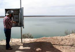
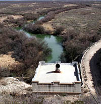
James Calaway, who has lived at Red Bluff Lake since 1982, checks the new monitoring equipment on Red Bluff Dam. Calaway, who has owned a cabin at the small lake for 25 years, keeps track of water level readings. |
Salt CedarsSurveying the river from atop Red Bluff Dam as it passes beyond the gates - only one of which is operational - James Calaway notes that "dams, irrigation and population" have played the greatest roles in changing the river. But the trees growing in its banks are thirsty contenders. Introduced in New Mexico near the turn of the century by government agencies and private landowners to help control bank erosion, salt cedars have grown downstream and now clog most of the river's banks along its trip through Texas. "I guess they gulp down as much as we release," muses Calaway, an employee of Red Bluff Water Power Control District who checks the lake's levels each day. There is more lament than jest in his words. According to the Pecos River Compact Commission, each adult salt cedar swallows up to 200 gallons of water every day. The mesquite bushes suck up what's left over, says Calaway. "They got roots that stretch all the way to China, I think." Several agencies now are working toward getting a special use permit to treat the trees with a powerful herbicide. Produced by American Cyanamid, the herbicide Arsenal has proven effective in the war against salt cedar in New Mexico, said Charlie Hart, an extension agent in Pecos County. After numerous salt cedars were treated with the chemical at Spring Lake, N.M., the water table rose more than six meters within three years, despite a mild drought, Hart said. Red Bluff, Texas A&M Extension Service, the Pecos River Compact Commission and American Cyanamid jointly requested the state exemption for Arsenal last fall, Hart said. "Salt cedars are a problem affecting the quality as well as the quantity" of river water, Hart said. "They actually suck salt from the soil and redeposit it in the river when they drop their leaves." Red Bluff manager Miller is pessimistic. The seemingly endless paperwork required has taken a great deal of energy and time, he said. Feed cattle have access to much of the river's waters, so the land along it is classified as grazing land. "There's nothing there for them to graze, but the cattle have access," said Hart. The fear is that the chemical, not yet approved for wetlands or grazing land application, could affect the quality of the cattle's beef. "They haven't proved that it won't," said Brad Newton, Texas commissioner of the Pecos River Compact Commission. A five-year study of the chemical's risk to livestock is due to be completed in 2000. |

Albert Wagner poses near his salt mining operation southeast of Loving, N.M. Wagner is mining a salt bed created in the 1960s by a federal project that prevented an underground salt stream from entering the Pecos River. The project was halted after it became difficult to dispose of the salt. Wagner is trying to revive the effort so he can market the salt. |
Malaga BendThe generators that originally converted moving water into electricity beneath the Red Bluff Dam are gone. But the Red Bluff district, created along with the dam in 1936 to manage its use, is still working to manage the river's waters. Stretching from the New Mexico border to Girvin, the Red Bluff district incorporates seven individual water districts, Miller said. The district is vitally interested in reducing the water's salinity. Salt concentrations in the river increase during extreme drought conditions, reaching levels at which the water cannot even be used for irrigation or feeding cattle, said Newton. A 1960s experiment may hold the solution to desalinizing the river, he said. A project of the federal Bureau of Reclamation, the underground Malaga Spring in the Rustler Aquifer was diverted into a small earth depression, where 120,000 gallons of spring water were deposited each year for about five years. Left to evaporate, the salt water ultimately left a thick deposit of salt, up to 12 feet deep in some places. Only then did the agency realize there was no market to sell the salt, and the project was abandoned. |

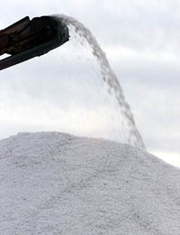
Water standing in pools at Loving Salt Ltd. is saturated with salt, which creates the green tint to the water. The water evaporates, leaving the salt behind. |
Thirty years passed.Now Red Bluff is working with the states of New Mexico and Texas, the Pecos River Compact Commission and a small, private company in Loving, N.M., to start pumping the Malaga again. "The experiment was a success. They did reduce the brine flow," said Albert Wagner, a part owner in Loving Salt, LTD, which hopes to market the salt. "As far back as 1907, everybody knew that the main concentrations of salt came from the Malaga." As Newton described the demise of the Bureau of Reclamation's project: "They had a real good idea. They just didn't know how to sell salt." Wagner's company has been busy excavating the prepared salt deposit since 1994. Now he hopes to expand to three rotating salt pools. "The beauty of this project is it is a commercial solution to an environmental problem," said Newton. Resuming the Malaga operation would reduce the river's salinity by 300 tons per day, said Newton. Farmers in Texas could lose as much as 600 acre-feet of water per year because of the desalination project, he said. Red Bluff would benefit from the project. Not only would the river's water quality be enhanced, but the district would receive 50 cents for every ton of salt sold by Loving Salt. |
Salt produced from a federal deslination project in New Mexico is being harvested and marketed by Loving Salt Ltd. The company is trying to revive the project to produce more salt. The pumping of an underground stream, as demonstrated by a federal project in the 1960s, would reduce the flow of salt into the Pecos River by 300 tons a day. |
PupfishThe legal wrangling over water rights between Texas and New Mexico ended in 1988. After a 17-year court case, the U.S. Supreme Court ruled that New Mexico must send Texas half of all available water in the Pecos River. New Mexico since has spent about $50 million complying with this order, Newton said. Replacing the headache that New Mexico had represented for Texas growers, a batch of small minnows that frequent tributaries and water pits around the river has been getting a lot of federal attention. The federally endangered Comanche Springs pupfish, the Leon Springs pupfish and the Pecos pupfish - recently proposed by the EPA to join their ranks - all have been threatened by an aggressive bait fish from shallow, salty waters along the Atlantic and Gulf coasts. Brought to West Texas around 1980, the sheepshead minnow has been threatening the genetic purity of other minnow species by aggressively inter-breeding with them. All are located in southern Reeves County and northern Pecos County. "The pupfish has almost been destroyed by two things: loss of habitat and hybridization with the sheepshead minnow," said Gary Garrett, a Texas Parks and Wildlife fisheries biologist. The Balmorhea Lake was subjected to a massive fish kill on Aug. 24, 1998, to eliminate the hybridized fish. The more hybridized fish, the greater the chance of more listed species, said Garrett. And more listed species would inevitably mean more government regulation of local water use, said Reeves County Water Improvement District No. 1 manager Joe Gallego. A public comment period on the proposal by the U.S. Fish and Wildlife Department to list the Pecos pupfish concludes this month. A conservation agreement that would turn protection of the fish over to a cooperative arrangement between private landowners and the U.S. Fish and Wildlife Department may be the result, said Garrett. "The goal is just to keep this fish from going extinct. We need the private landowners. There is no way we can do it without them," Garrett said. To gain their support, the U.S. Fish and Wildlife Department and Texas Parks and Wildlife officials are offering to convert areas of private property into wetlands capable of supporting the pupfish. Portions of those wetlands would be open to use by cattle. So far, one landowner near Grandfalls has expressed interest in the project, said Garrett, and the state of Texas "all the way to the governor's office," is supportive of the agreement. But the larger challenge is preserving and repairing the Pecos River. "You don't have to be an expert to go out and look at the Pecos and say, 'That's not a beautiful stream,'" said Garrett. "It's not the beautiful river it was a long time ago. I think it's a worthwhile project, even though it is problematic." |